The Belgian soil map is due for an update. The soil drainage class is one of the most important parameters in the development of models and applications in the context of drought and flooding. Yet, the classes are partly outdated and therefore less reliable. Hence the Flemish Environment Department is looking for a new method to update the soil map based on groundwater statistics and geostatistical analyses. Antea Group joins forces with Prof. Peter Finke from UGent to work on a smart solution for an up-to-date soil map.

The importance of data

Global warming is a fact. We know that measures against its negative effects, such as heat stress, drought and flooding are unavoidable. But how to determine which measures will be most effective? We must make sure that governments are well-informed and make decisions based on correct data and the most up-to-date information.

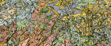
Let’s take the Belgian soil map as an example. The soil drainage class is one of the most commonly used parameters in the development of models and applications for agriculture, hydrology, ecology… However, these classes have not been updated since they were introduced during the soil mapping of 1947-1974. Since then, significant alterations may have occurred locally due to drainage, land embankments, excavations, groundwater extraction and desiccation. This makes it difficult to draw sound conclusions based on the existing drainage classes – precisely because they might be outdated and thus no longer relevant.

Update of the soil map

Together with the Flemish Department of Environment and University of Ghent, in a quadruple helix structure, we are developing a method that allows us to continuously update the map based on relevant environmental data and new groundwater level measurements. We combine Prof. Peter Finke’s knowledge in soil science and geostatistics with Antea Group's machine learning and remote sensing expertise, linking the drainage classes to field and satellite observations. We also regularly ask the end users of the soil map for feedback. This way, we make sure that the new data can be found with ease and efficiently.
The end result of this holistic approach is a smart model for an up-to-date soil map that is more reliable, relevant and smarter! This way, Flanders will soon be able to make sound decisions for the development of future-oriented and climate-proof solutions.