The Kerkebeekpark in Bruges
Logo Antea Group - No text - Angled - Transparent

Questions? Let's get in touch.

From grey to green infrastructure

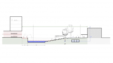
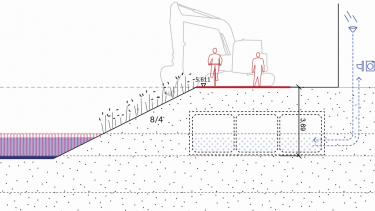
The resurfacing of the 'Kerkebeek' and the redevelopment of the 'Kerkebeekpad' as a cycling and walking path was an assignment for the City of Bruges, initiated by the European project 'Nature Smart Cities'. Where classic watercourse resurfacing projects mainly focus on grey infrastructure, we structurally and thoroughly searched for green added value; from grey to green infrastructure! That's why we've deployed the principles and tools for determining and calculating ecosystem services from the very first phases of the project. This has been crucial for the success of this sustainable and climate-adaptive spatial framework plan.

The assignment

Currently, the Kerkebeek is largely built in underground. In the context of 'Nature Smart Cities', the City of Bruges wanted to investigate the possibilities for resurfacing the Kerkebeek again as much as possible, while creating a cycling and walking connection. This way the project not only serves as a lever for improved mobility, but also for increasing ecological quality and climate-adaptive functions within an urban context. Even more so, thanks to a nature-inclusive design, the future Kerkebeekpad should contribute to local biodiversity as well as provide ecosystem services to the city and its inhabitants — in the form of water and air quality, reducing flood risk, urban cooling, health and well-being.

So the central question of this project wasn't whether we wanted to open up the Kerkebeek, or whether we wanted to design the Kerkebeekpad as a central slow axis. But rather how we could leverage both to create maximum added value: "The Kerkebeekpark as an ecological corridor between the city belt and the green belt".

From grey to green infrastructure

The solution

Enclosing water used to be a driver for urban development. With this project, we aimed to turn this trend around by resurfacing the Kerkebeek in the city. By analysing existing structures (duct, overflows, ...) and (water) levels, it quickly became apparent what opportunities and bottlenecks would form the preconditions. It also inspired some innovative ideas, such as using the existing ducts as a rainwater buffer. This way, water became a driver for opportunity instead of a bottleneck!

The vision for the project area was translated into an integral spatial framework plan. The preconditions of the desired spatial plan were established and visualised in various sub-areas. As a design plan, it enables conversation and contributes to dialogue, coordination, etc. Therefore it's not a master plan, but a framework for the further development of the site.

(Re)designing the public space in function of the climate is no longer exceptional. However, deploying the principles and tools for determining and calculating ecosystem services early in the design phase is. This is how we made the aspects of climate adaptation and sustainability, that are often difficult to concretise, tangible. It allowed us to make certain choices sooner in the process and to gradually raise awareness and public support.

Visualisations

Timeline slide

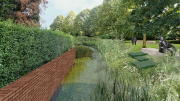
Future vision: serene seating by the water ties in with the idea of an open cemetery

Timeline slide

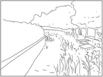
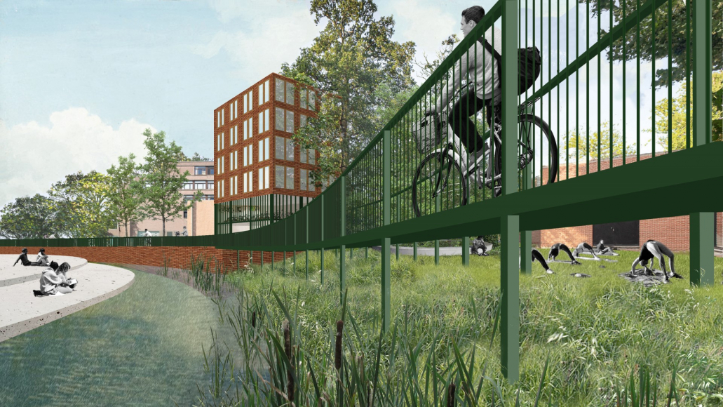
Sketch: cultural and regulatory ecosystem services and biodiversity

Timeline slide

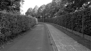
Current situation: the Kerkebeekpad alongside the cemetery (on the right)

The result

  • 20,856 m³/year Avoided rainwater runoff
  • 26,400 m³/year Water buffering in existing tubes
  • 134.5 kg/year Water treatment (nitrogen removal)
  • 27.4 kg PM10/year Air purification

Partnerships and collaborations

A supported framework plan for the Kerkebeek and the Kerkebeekpad is the product of a year of intensive collaboration:

  • Antea Group was part of the design team together with Maat-Ontwerpers.
  • We went through a process of continuous coordination with the client City of Bruges and the most important stakeholder (owner and manager of the watercourse) the VMM.
  • Within the Nature Smart Cities framework, the University of Ghent and the University of Antwerp were involved in the quantification of ecosystem services.
  • The Nature Value Explorer of VITO was used to determine and assess the ecosystem services.

SDG's

Met dit project ondersteunen wij de Duurzame Ontwikkelingsdoelstellingen van de Verenigde Naties:

SDG 3 - Goede gezondheid en welzijnSDG 11 - Duurzame steden en gemeenschappenSDG 13 - KlimaatactieSDG 14 - Leven onder waterSDG 15 - Leven op het landSDG 16 - Vrede, justitie en sterke publieke dienstenSDG 17 - Partnerschappen

Want to know about this project?

Let's get in touch!

This website uses cookies.

Select the type of cookies you want to accept

More information