Coastal observation toolbox
Logo Antea Group - No text - Angled - Transparent

Coastal observation toolbox

Questions? Let's get in touch.

Ask a question

Smart observation toolbox for a safer coastal area

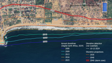
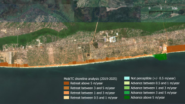
Our coastal areas are under pressure: rising sea levels, erosion, and changing weather patterns bring new risks. Reliable data, however, is often difficult or expensive to obtain, making timely and well-founded action challenging. That’s why we at Antea Group developed the Coastal Observation Toolbox.This toolbox collects and processes up-to-date remote sensing data on coastal areas and presents the results clearly. With satellite images and advanced analytical tools, you can track changes, identify risks, and gain insights for future scenarios.

Smart observation toolbox for a safer coastal area

How does the toolbox work?

  1. Data collection
    Our toolbox uses satellite images from Copernicus, the European Earth observation program. These images are available worldwide, of high resolution, and updated every 5 to 10 days.
  2. Automated data processing
    The collected data is automatically analyzed:
    a. Images are improved, for example through light adjustments and cloud filtering.
    b. Algorithms detect and measure coastlines, water depths, and historical changes.
    c. Vegetation and water indices provide additional insights into environmental conditions.
  3. Expert Analysis
    Based on the processed data, our coastal experts provide:
    a. Monitoring: weekly timelapse videos to track changes over time.
    b. Analysis: dynamic maps and reports that clarify trends and current conditions, showing you areas in accretion and erosion
    c. Prediction: scenarios and forecasts for future-proof policy and management

Applicable to various areas

Although we originally developed the toolbox for coastal management, it can also be applied to:

  • Environmental management: ecosystem restoration, vegetation monitoring, and disaster prevention
  • Water management: flood analysis, water quality, and turbidity
  • Spatial & urban planning: agriculture, land use, and climate adaptation in cities
  • Infrastructure: monitoring large projects such as ports, railways, roads, and offshore wind farms

With the Coastal Observation Toolbox, organizations can base their decisions on current, reliable information. The assessment is time and cost efficient, which ensures resources are used more effectively.

Interested in the Coastal Observation Toolbox?
Contact us!

* Required field


Curious about how we handle your data? You can read about this in the privacy and cookie policy

Want to know more about this toolbox?

We are happy to help!

Smart observation toolbox for a safer coastal area
Ask a question